
For a different introduction to Cottesloe, start with a  Cottesloe Flour Mill (former).
On Athelstan Road, the brick Cottesloe Flour Mill now contains apartments. The mill and adjoining works once milled wheat, generated electricity and manufactured pressed-metal ceilings: a reminder that people came to Cott to make a living as well as spend a day off. (Heritage Council of WA: Cottesloe Flour Mill)
Before the street names
At the southern end of  Cottesloe Beach,
 Mudurup Rocks is a place of fishing, ceremony and continuing spiritual significance on Whadjuk Noongar Country. Its name is translated as “place of whiting”, recalling the fish that drew families to these shallows in summer. (Cottesloe Past: Aboriginal history; Ken Macintyre and Dr Barb Dobson: Indigenous significance of Mudurup)
Noel Nannup describes women using paperbark branches to herd fish into one area, where men caught them with gidgees, or spears. Food came from the dunes too: pigface fruit, quandongs and wattle seeds were part of a detailed knowledge of what the coastal landscape could provide. (Cottesloe Past: Aboriginal history)
The birds carried stories as well. Mudurup is associated with Kadjil the powerful Crow Man, who could take human or crow form. In an account shared by Elder Corrie Bodney, Kadjil foretold approaching storms through the calls of black cockatoos and the busy movements of ants. Crows arriving from Wadjemup, now also known as Rottnest Island, heralded the coming of mullet and salmon. Land, weather, wildlife and spiritual life were all closely connected. (Ken Macintyre and Dr Barb Dobson: Indigenous significance of Mudurup)
Bodney also recalled his own childhood here. In the 1940s and 1950s, he and his brothers speared whiting using homemade gidgees fashioned from fencing wire and broom handles. (Ken Macintyre and Dr Barb Dobson: Indigenous significance of Mudurup)
“We always brought back a good feed for our family,” he told anthropologists Ken Macintyre and Barb Dobson. His recollection brings Aboriginal life into the same decades as the beach holidays in old family photographs, rather than leaving it somewhere in a distant past. (Ken Macintyre and Dr Barb Dobson: Indigenous significance of Mudurup)
Elders consulted by the researchers described Mudurup as extending across the high ground, shoreline and reef, including places later altered by buildings and the  Cottesloe Groyne. The headland visitors see today is only part of that cultural landscape. (Ken Macintyre and Dr Barb Dobson: Indigenous significance of Mudurup)
The coast was a seasonal home for Whadjuk Noongar families, who came to fish and gather food in the warmer months and moved inland as winter approached. (Ken Macintyre and Dr Barb Dobson: Indigenous significance of Mudurup) Inland from Swanbourne Beach, Aboriginal families were still living around Narla Road near Lake Claremont until 1951. (WA Government: Swanbourne school site and occupation until 1951; WA Government: Swanbourne and Lake Claremont homeground) A heritage record also identifies a camp and scattered artefacts near  Victoria Street Train Station, though it does not date their use. (Aboriginal Heritage Inquiry System: Victoria Street Station, 2010)
A place on the way
Willem de Vlamingh’s Dutch expedition reached this coast in January 1697. The  Vlamingh Memorial commemorates a presumed nearby landing place: an arrival in an already inhabited landscape, not its discovery. (Town of Cottesloe: History and heritage)
British colonisation from 1829 brought dispossession and introduced diseases across Noongar Country, followed by restrictions on movement, employment and family life. Whadjuk connection to Country endured through these changes. (WA Government: Noongar Recognition Bill historical background)
For people travelling between Perth and Fremantle, successive establishments called the Halfway House offered somewhere to stop, including one on the later  Albion Hotel site. (Cottesloe Past: Before Cottesloe)
The railway opened in 1881, subdivision followed, and Cottesloe was named in 1886. Gold-rush population growth and land sales helped turn a stopping place into a seaside destination. That history still shapes a visit:  Cottesloe Village grew beside the railway, while another centre of activity gathered at the ocean. (Cottesloe Past: Before Cottesloe)
The Cott that went to work
In the early 1900s, Splatt, Wall & Co’s pressed-metal works beside the Cottesloe Flour Mill (former) supplied decorative ceilings, including for His Majesty’s Theatre in Perth. Not all the industrial output was so welcome: in 1908, the milling company was told to stop letting oil and grease run onto Railway Street. (Heritage Council of WA: Cottesloe Flour Mill)
Arthur “Gidge” Carter, whose parents both worked at the mill, remembered steam trains bringing wheat through the suburb. (The Grove: Arthur “Gidge” Carter)
Limestone was another local trade. Briggs & Co operated quarries and lime kilns, including at the site now marked as  Former Briggs Quarry on Nailsworth Street. Some stone was cut into building blocks; some was heated to make quicklime, then mixed with water to produce slaked lime used in mortar to bind bricks and stone, and in plaster to finish walls. (Heritage Council of WA: Briggs Quarry and lime kilns; WA Government: Lime production and building uses)
During the Depression, unemployed men worked under a relief scheme to meet rates bills and earn a little more. Some filled old quarries. Holes left by one period of employment became the work of another. (Heritage Council of WA: Briggs Quarry and lime kilns)
The cottage and the mansion
Cott’s housing story is not simply workers’ cottages giving way to million-dollar mansions. The heritage survey records modest homes in Boreham Street and rental cottages in John Street alongside substantial early seaside residences. (Town of Cottesloe: Local Heritage Survey 2025)
John and Elsie Curtin built their  Curtin Family Home on Jarrad Street in 1923: four brick rooms and verandahs on three sides. John would become Australia’s wartime prime minister, serving from 1941 to 1945. (John Curtin Prime Ministerial Library: Home for a growing family; National Archives of Australia: John Curtin fast facts)
The railway was nearer than the beach, useful for this city worker who never owned a car. Behind the Curtin house were a toilet by the fence, a woodpile, a laundry copper and a vegetable patch. There were books indoors, washing to do and cricket in the backyard. (John Curtin Prime Ministerial Library: Home for a growing family)
Meanwhile, Claude de Bernales had bought Judge Pennefather’s property in 1911, renamed it Overton Lodge and later transformed it into a Spanish-style mansion. For decades, the bungalow and the grand estate belonged to the same suburb. (Town of Cottesloe: History and heritage)
Today’s multimillion-dollar property market adds another twist: a cottage need not grow into a mansion to become expensive. Preserving a small house’s shape does not necessarily preserve an affordable place to live. (REIWA: Cottesloe suburb profile)
A day at the beach
While some people worked here, others came to escape work.
An early-twentieth-century outing might mean a promenade, a picnic and a band playing on the jetty, with a swim optional. Mr Page’s bathing machines offered privacy for those taking the plunge: hired by the hour, the little cabins were wheeled to the water’s edge and hauled back up the beach by a horse at day’s end. (Cottesloe Past: Sandcastles and greasy pigs)
A modern towel-and-togs expedition requires less organisation, but the pleasure of a few hours beside the sea is still the same.
Growing crowds also needed rescuers.  Cottesloe Surf Life Saving Club formed in 1909, combining beach safety with sport, carnivals and a social life. The beach brought people together; the club gave them reasons to keep turning up for one another. (Cottesloe Surf Life Saving Club: Club history)
Even the postcard has changed
The Norfolk Island pines feel inseparable from Cott, yet they were once newcomers. The Town dates early plantings in John and Broome Streets to 1908, with residents helping nurture them. (Town of Cottesloe: History and heritage)
The beach itself has been reshaped. By the 1950s, winter storms could expose an uninviting stretch of rock. Construction of the Cottesloe Groyne began in 1960, helping sand accumulate. A childhood memory of the “natural” beach may include a major engineering intervention. (Cottesloe Past: A new groyne)
Indiana’s story is more complicated still.
The original Indiana Tea House was a timber-and-iron establishment beside the jetty. Cottesloe Past records Miss Tessa Donovan opening it in September 1913, with refreshments and, later, dancing drawing visitors to the water’s edge. (Cottesloe Past: Tearooms and skating rinks)
When the Centenary Bathing Pavilion opened nearby in 1929, the two buildings stood together. The old tea house, later renamed the Kit Kat Cabaret, was removed in 1933. (Cottesloe Past: The most romantic place; Sculpture by the Sea: Indiana Tea Rooms)
The pavilion lasted until 1982, when deterioration and a report finding restoration uneconomic led to demolition. A smaller replacement opened in 1983. (Cottesloe Past: Demolition of the pavilion)
Today’s Indiana Teahouse, designed by Scanlan Architects, opened in October 1996. It borrowed its name from the timber tea house, its architectural inspiration from the Centenary Pavilion, and incorporated the 1983 building beneath it. Yet this relatively young building holds a surprisingly strong place in people’s affections, woven into years of swims, sunsets and beach days. (Scanlan Architects: Indiana Tea House; Cottesloe Past: Demolition of the pavilion)
What disappeared, and what found another life
Some losses occupy just one word in the heritage survey. An early Loma Street cottage, once owned by a stonemason, is recorded as “Demolished.” With such houses goes evidence of ordinary life. (Town of Cottesloe: Local Heritage Survey 2025)
The Cottesloe Flour Mill (former)’s survival was not automatic either. A 1992 stop-work order halted demolition while ways of retaining significant buildings were explored. Its later conversion to apartments preserved part of industrial Cott, though not the industry itself. (WA Government: Cottesloe Flour Mill stop-work order; Heritage Council of WA: Cottesloe Flour Mill)
Overton Lodge took a different turn. In 1950, the private estate became the Town Hall and Cottesloe Civic Centre and grounds, giving the public access to grand gardens once attached to a mansion. (Town of Cottesloe: History and heritage)
At  Boatshed Market, the name preserves another working life. Australia II, the yacht that won the America’s Cup in 1983, was built on this site. The food market opened in 1988. (Boatshed Market: About us)
The dunes grow back
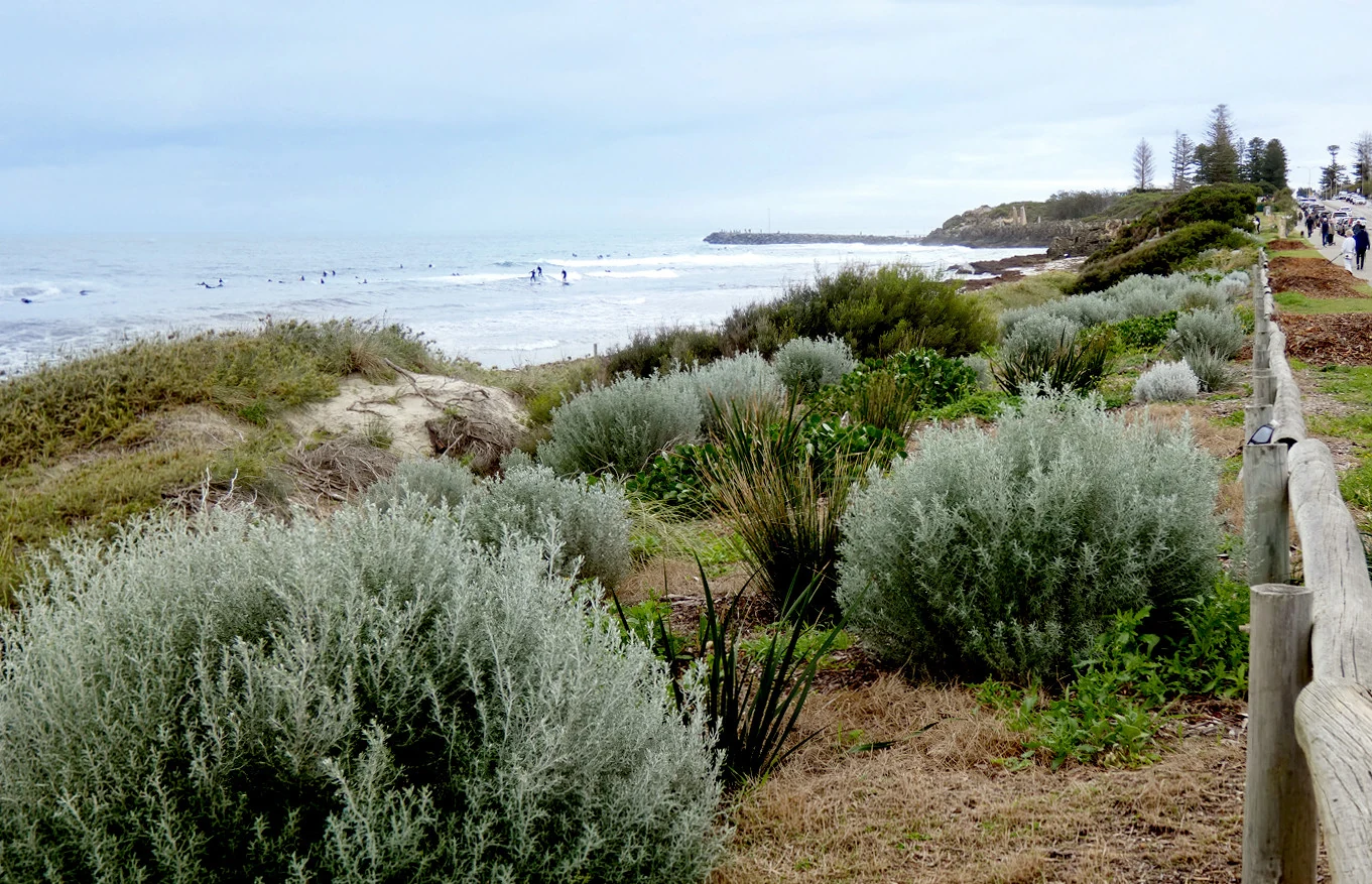
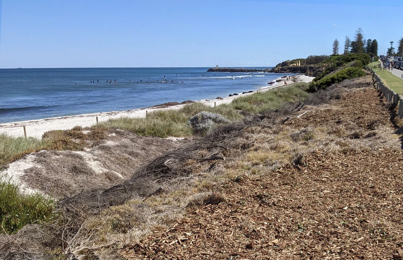
Buildings are only part of Cott’s story. Cottesloe Coastcare began in 1995 and expanded its work to all four kilometres of Cottesloe’s coast in 2001. (Cottesloe Coastcare: Our history) By 2026, Coastcare reports that its volunteers have planted more than 150,000 plants and restored most of the degraded dune system, along with two other important natural areas:  Grant Marine Park and Playground and
 Cottesloe Native Garden. (Cottesloe Coastcare: update supplied for this guide, October 2026) Year after year, local volunteers, school students and corporate teams keep planting, weeding, mulching, watering and collecting seed. In 2025, for example, they contributed more than 1,600 hours. (Cottesloe Coastcare: Caring for the Cottesloe dunes in 2025)
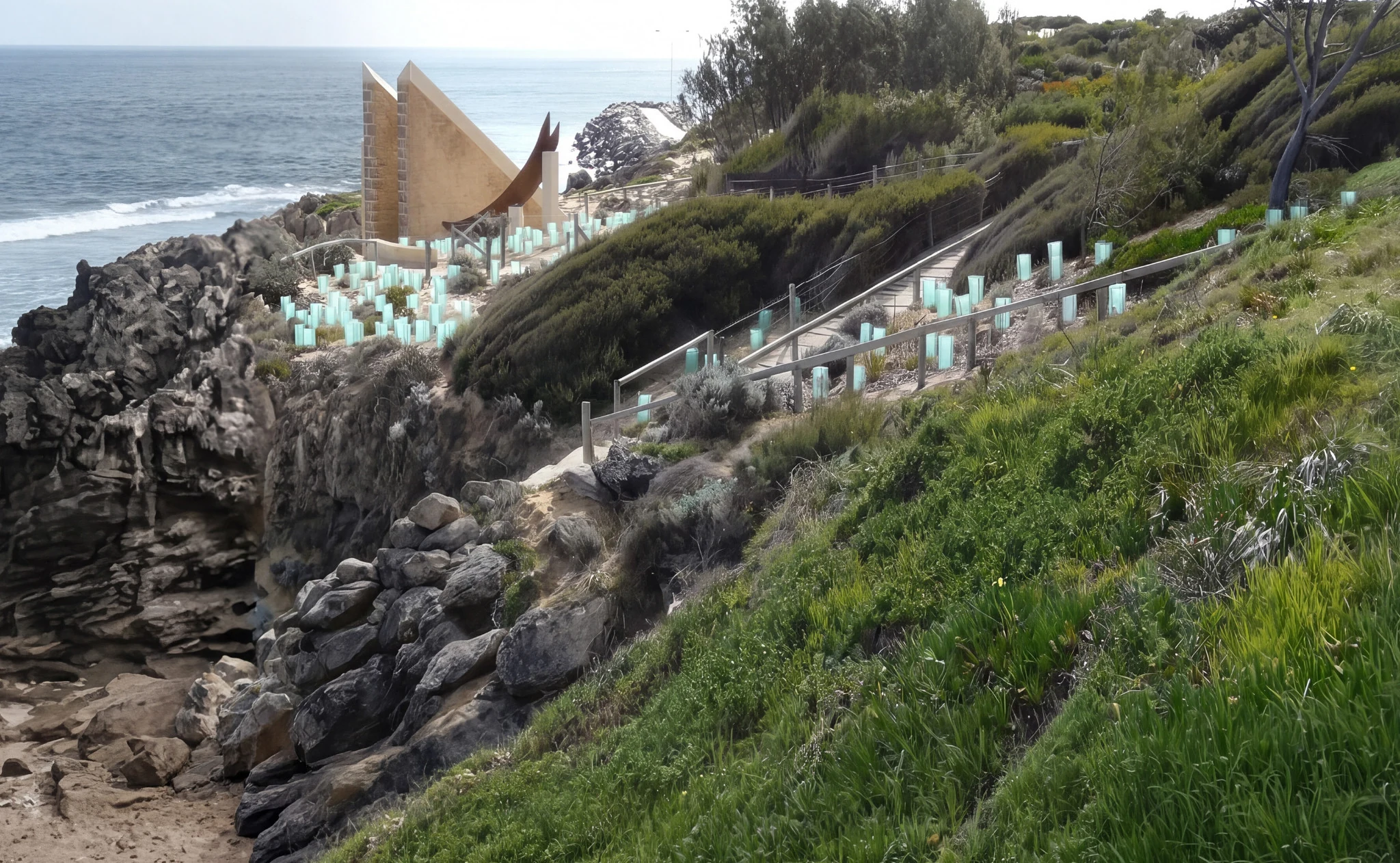
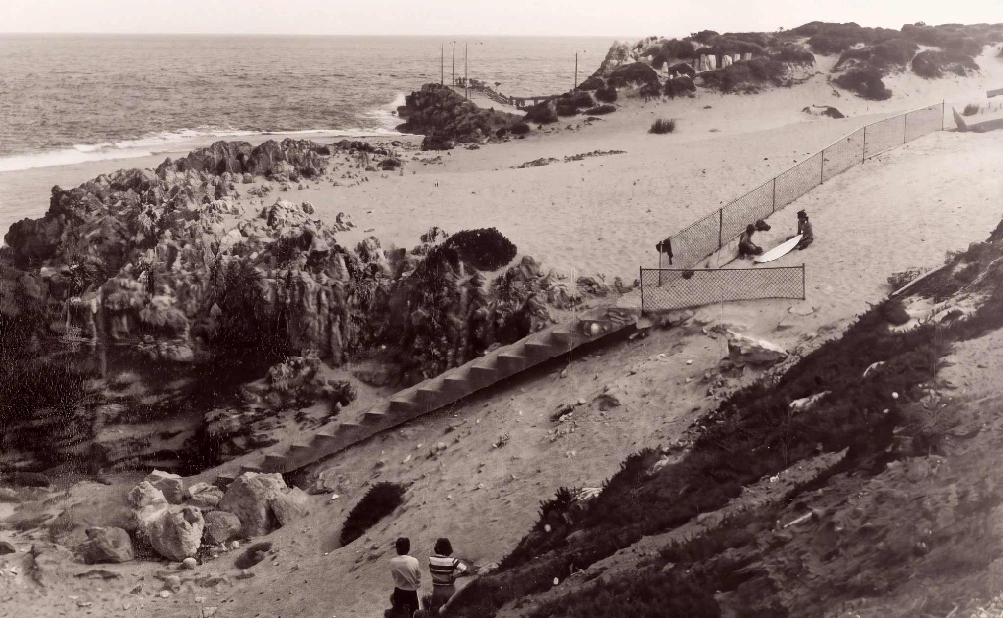
The group has also helped preserve Cottesloe’s local quandong population. In 2009, two Coastcare volunteers propagated ten root suckers from what the group records as the suburb’s last remaining patch, near the WA Foundation for Deaf Children, and planted them at Grant Marine Park. The trees thrived and began producing new suckers of their own. (Cottesloe Coastcare: Grant Marine Park)
Restoring the dunes helps protect them from erosion, makes the coast a greener, more welcoming place to spend time and creates habitat for local wildlife. White-winged fairy-wrens, bobtails and other wildlife have returned to the dunes. (Cottesloe Coastcare: Our history; Cottesloe Coastcare: Grant Marine Park; Cottesloe Coastcare: update supplied for this guide, October 2026)
The next Cott
Offshore, the reef is now a Fish Habitat Protection Area. On land, the Town’s coastal hazard planning considers erosion, flooding and rising sea levels. The coastline earlier generations quarried, engineered and landscaped will keep changing, along with its homes and public places. (Town of Cottesloe: Fish Habitat Protection Area; Town of Cottesloe: Coastal hazard planning)
There is no single past to which the whole of Cottesloe could be returned. The Cottesloe Flour Mill (former), the cottage, the grand estate and living Whadjuk Country hold different histories.
Next time you walk through Cott, the sea will probably draw your attention first. Let it. Then look inland at the buildings, the trees and the spaces between them.
There is more of Cottesloe there than the postcard can hold.
Sources and further reading
Prepared: 6 October 2026
Text and layout updated: 22 October 2026
Researched and edited by CottBuzz